Dale Farm, the reality of Green Belt in Basildon.
TB | 19.10.2011 21:51 | Dale Farm | Analysis | Policing | Repression
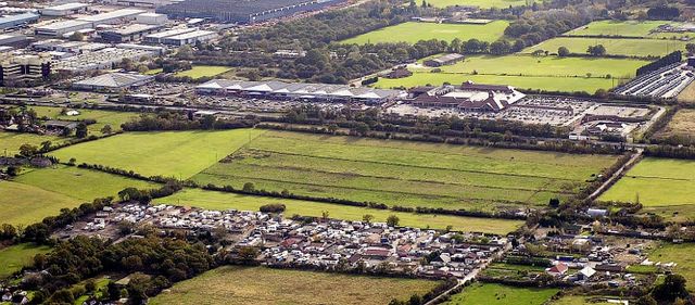
Dale Farm and industrial Basildon.
BBC version.

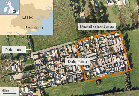
Basildon District Council version.
This image shows at the bottom the traveller Dale Farm site which has not been extended beyond the perimeter that you see here. The site is pretty much the same now as it was back then, although recent images do appear to show some depopulation. You can also see at the top, large-scale development including a retail park, sports playing field's, and in the top right hand corner, a large industrial park containing factories, businesses and some large international corporations. The rent paid by these businesses and corporations is way and above enough to help find the travellers a place to go. The dividing line between these developments is the A127, a very busy arterial road that runs from London right through to Southend on Sea. It is one of the busiest arterial roads in England.
The land at the top of the image beyond and including the developemts is excusively under private ownership so there are no public spaces or right of way there at all.
This image is one you are unlikely to see printed in the MSM because it shows clearly that the general area is already in a state of advanced development. The images you will see printed and online in the MSM, will only show the traveller site looking in the opposite direction. This is because the traveller site can then be placed with a green countryside background emphasising the 'green belt' angle which the MSM wish to show. This is probably because the MSM doesn't particularly want to burn its bridges with the government, which clearly is fully backing the violent and shocking behaviour we have seen today.
The second image is from the BBC, that bastion of competency and fair mindedness. This image shows a directly overhead view that clearly isn't of any real value. Although it does helpfully allow you to make a judgement about what bit of the site is good, and therefore, what bit is bad.
The third image is taken from Basildon Council's own website and is clearly a litle more helpful, although is still taken from an angle looking away from the bulk of industrial development in the town.
TB
Comments
Display the following comment